- Sagaing
Infobox Settlement
official_name = Sagaing
other_name =
native_name = _my. စစ်ကိုင်းမြို့
nickname =
settlement_type =
motto =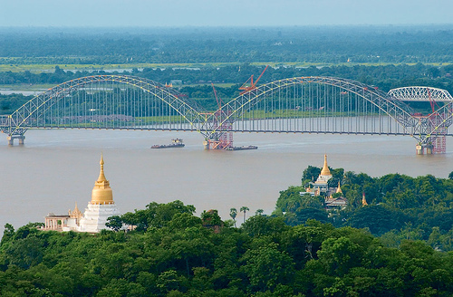
imagesize = 300px
image_caption = The Ava Bridge on the Irwaddy
flag_size =
image_
seal_size =
image_shield =
shield_size =
image_blank_emblem =
blank_emblem_type =
blank_emblem_size =
mapsize =
map_caption =
mapsize1 =
map_caption1 =
image_dot_
dot_mapsize =
dot_map_caption =
dot_x = |dot_y =
pushpin_
pushpin_label_position =bottom
pushpin_map_caption =Location in Burma
subdivision_type = Country
subdivision_name =Burma
subdivision_type1 = Admin. division
subdivision_name1 =Sagaing Division
subdivision_type2 =
subdivision_name2 =
subdivision_type3 =
subdivision_name3 =
subdivision_type4 =
subdivision_name4 =
government_footnotes =
government_type =
leader_title =Mayor
leader_name =
leader_title1 =
leader_name1 =
leader_title2 =
leader_name2 =
leader_title3 =
leader_name3 =
leader_title4 =
leader_name4 =
established_title =
established_date =
established_title2 =
established_date2 =
established_title3 =
established_date3 =
area_magnitude =
unit_pref =Imperial
area_footnotes =
area_total_km2 =
area_land_km2 =
area_water_km2 =
area_total_sq_mi =
area_land_sq_mi =
area_water_sq_mi =
area_water_percent =
area_urban_km2 =
area_urban_sq_mi =
area_metro_km2 =
area_metro_sq_mi =
area_blank1_title =
area_blank1_km2 =
area_blank1_sq_mi =
population_as_of =2005
population_footnotes =
population_note =
population_total =
population_density_km2 =
population_density_sq_mi =
population_metro =
population_density_metro_km2 =
population_density_metro_sq_mi =
population_urban =
population_density_urban_km2 =
population_density_urban_sq_mi =
population_blank1_title =Ethnicities
population_blank1 =
population_blank2_title =Religions
population_blank2 =Buddhism
population_density_blank1_km2 =
population_density_blank1_sq_mi =
timezone =
utc_offset =
timezone_DST =
utc_offset_DST =
latd=21 |latm=52 |lats=56 |latNS=N
longd=95 |longm=58 |longs=43 |longEW=E
elevation_footnotes =
elevation_m =
elevation_ft =
postal_code_type =
postal_code =
area_code =
blank_name =
blank_info =
blank1_name =
blank1_info =
website =
footnotes =Sagaing (MYname|MY=စစ်ကိုင်းမြို့|MLCTS=sac kuing: mrui.; population estimate 300,000) is the chief city and capital of
Sagaing Division in Myanmar. It is located on theAyeyarwady River , 20 km to the southwest ofMandalay on the opposite bank of the river.Sagaing is a religious and monastic center, with numerous
Buddhist monasteries . It briefly held position as a royalcapital of Burma from 1760-1764.The British-built 16 span
Ava Bridge connects Sagaing with Mandalay, and tourists frequently visit Sagaing as a day trip. Onetourist favorite located near the city is theMingun Bell , claimed to be the world's largest ringing bell. Its weight of 55555 viss (approximately 90 metric tons) is engraved into the front side.The city is home to the
Sagaing Institute of Education and theSagaing Education College .People
*
Zhu Youlang, Prince of Gui , lastMing Dynasty claimant toChina , lived in exile at Sagaing in 1661.
*Maurice Collis , author of "Trials in Burma ", was district commissioner of the Sagaing district in 1928.

Wikimedia Foundation. 2010.